Looking for a safe, scenic place to cycle without worrying about cars? This guide pulls together the UK’s best traffic-free cycle routes, broken down county by county across England, Wales, and Scotland.
Over 150 trails included
Focus on rail trails, canal paths, coastal rides, and forest greenways
Each listing shows:
Trail name
Location
Length
Estimated % traffic-free
Ideal for families, beginners, leisure cyclists, or anyone avoiding road traffic
If you’re looking to explore the UK by bike without the stress of traffic, this comprehensive guide to traffic-free trails is a great place to start. From coastal paths in Wales to canal towpaths in Scotland and woodland greenways across England, there’s something here for every family.
Many of these trails are also suitable for walking, wheelchair users, or even running buggies, making them perfect for inclusive outdoor adventures.
All the routes are, most importantly, family-friendly, and you can travel as much or as little of the route as you like.
We need your help!
Have you cycled any of the trails listed — either solo or with your family? Got photos, tips, or feedback? We're just one family doing our best to explore the UK, but we know there's a huge community of cyclists out there who can help.
If you'd like to contribute a route review for our website, we’d love to hear from you.
Note: Follows a former railway (Sewell Greenway) and paths along chalk grasslands. Connects Luton and Dunstable with mostly off-road trail .
Berkshire
Trail Name
Location (Towns)
Length
Est. % Traffic-Free
Kennet & Avon Canal Path
Reading to Bath (via Newbury, Devizes)
~85 miles (137 km)
~95%
Note: Long towpath route along the Kennet & Avon Canal. Largely off-road aside from short on-road detours in towns (e.g., Newbury) .
Buckinghamshire
Trail Name
Location (Towns)
Length
Est. % Traffic-Free
Phoenix Trail
Thame to Princes Risborough
7.5 miles (12 km)
~98%
Note: Rail-trail with a smooth surface, part of NCN Route Phoenix Trail. Only a short minor-road section near Princes Risborough .
Cambridgeshire
Trail Name
Location (Towns)
Length
Est. % Traffic-Free
Cambridge–St Ives Busway Path
Cambridge to St Ives
16 miles (26 km)
100% (traffic-free guided busway path)
Note: Follows the guided busway corridor. Completely segregated from traffic; popular for cycling and walking.
Cheshire
Trail Name
Location (Towns)
Length
Est. % Traffic-Free
Chester Millennium Greenway
Chester (Sealand to Mickle Trafford)
7.4 miles (12 km)
100%
Middlewood Way
Macclesfield to Marple
11 miles (18 km)
100%
Note: Both are former railway lines converted to multi-use trails. The Chester Greenway follows the old railway through Chester, and the Middlewood Way runs along the former Macclesfield–Marple line, fully off-road.
Cornwall
Trail Name
Location (Towns)
Length
Est. % Traffic-Free
Camel Trail
Padstow – Wadebridge – Bodmin – Wenfordbridge
17–18 miles (27–29 km)
~100%
Clay Trails (St Austell–Eden Project)
St Austell to Eden Project (via Clay Country)
~11.9 miles (19 km)
~95%
St Austell–Mevagissey Trail
St Austell to Mevagissey (Pentewan Trail)
~6 miles (10 km)
~80%
Note: The Camel Trail is one of Britain’s most popular rail-trails, nearly completely traffic-free over its entire length. The Clay Trails around St Austell (including routes to the Eden Project) run on dedicated paths through former china clay pits. The Pentewan Valley segment from St Austell toward Mevagissey is mostly off-road, with brief on-road sections near the start.
County Durham
Trail Name
Location (Towns)
Length
Est. % Traffic-Free
Derwent Walk
Consett to Swalwell (Gateshead)
12 miles (19 km)
100%
Waskerley Way
Stanhope to Consett
9 miles (14 km)
100%
Lanchester Valley Path
Consett to Durham (Broompark)
12 miles (19 km)
100%
Note: These three rail-trails form part of the renowned C2C route. They are entirely off-road along disused railway lines through County Durham’s countryside.
Cumbria
Trail Name
Location (Towns)
Length
Est. % Traffic-Free
Whitehaven–Workington Railway Path
Whitehaven to Workington
12 miles (19 km)
100%
Whitehaven–Rowrah Cycle Trail
Whitehaven to Rowrah (C2C start)
11 miles (18 km)
~95%
Note: These former railway paths provide scenic, flat rides along the Solway Coast and into West Cumbria. They form the western end of long-distance routes (C2C and Reivers), and are virtually entirely motor-traffic-free.
Derbyshire
Trail Name
Location (Towns)
Length
Est. % Traffic-Free
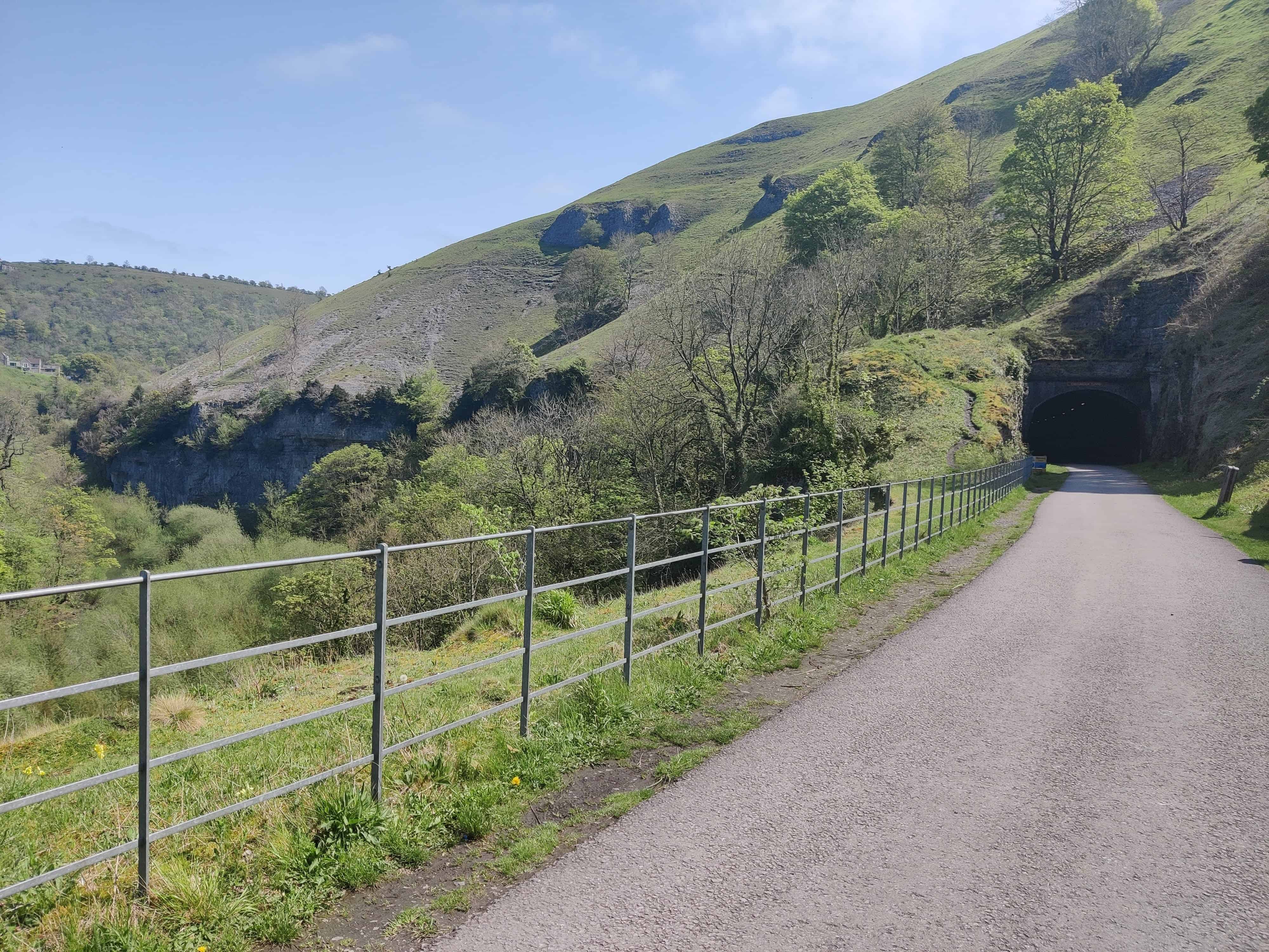
Monsal Trail
Wye Dale to Bakewell
8.5 miles (13.5 km)
100%
Tissington Trail
Ashbourne to Parsley Hay
13 miles (21 km)
100%
High Peak Trail
Cromford to Dowlow (near Buxton)
17.5 miles (28 km)
100%
Longdendale Trail
Hadfield to Woodhead
8 miles (13 km)
100%
Note: All are former railway lines through the Peak District. They feature tunnels (e.g., Monsal Trail’s lit tunnels) and viaducts, and are entirely off-road recreational trails.
Devon
Trail Name
Location (Towns)
Length
Est. % Traffic-Free
Tarka Trail
Braunton to Meeth (via Barnstaple)
30–32 miles (48–51 km)
~100%
Granite Way
Okehampton to Lydford
9 miles (14 km)
100%
Drake’s Trail
Plymouth to Tavistock (NCN27)
20 miles (32 km)
~90%
Exe Estuary Trail
Exmouth to Dawlish (via Exeter)
13 miles (21 km)
~80%
Dart Valley Trail
Totnes to Dartmouth area
6.3 miles (10 km)
~60%
Note: Devon boasts some of the UK’s longest continuous traffic-free paths. The Tarka Trail is almost entirely traffic-free (former railway). The Granite Way follows an old railway along Dartmoor’s edge. Drake’s Trail (including the Plym Valley Trail) is largely off-road through wooded valleys and tunnels. The Exe Estuary Trail uses dedicated paths alongside the estuary. (Dart Valley includes some on-road segments but is a scenic mostly off-road route along the Dart.)
Dorset
Trail Name
Location (Towns)
Length
Est. % Traffic-Free
Rodwell Trail
Weymouth to Portland
3.5 miles (5.6 km)
100%
Castleman Trailway
Ringwood to Poole
16.5 miles (26.5 km)
~80%
Note:Rodwell Trail follows a disused railway. Castleman Trailway is more mixed, with surfaced paths and some quiet lanes.
East Riding of Yorkshire
Trail Name
Location (Towns)
Length
Est. % Traffic-Free
Yorkshire Wolds Way (NCN 1 segments)
Hessle to Beverley
10 miles (16 km)
~85%
Hornsea Rail Trail (Trans Pennine Trail East)
Hull to Hornsea
15 miles (24 km)
100%
Note: The Hornsea Rail Trail is fully off-road and ideal for families, while the Wolds Way overlaps with NCN routes offering a mix of quiet lanes and traffic-free paths.
East Sussex
Trail Name
Location (Towns)
Length
Est. % Traffic-Free
Cuckoo Trail
Polegate to Heathfield
11 miles (18 km)
100%
Forest Way
East Grinstead to Groombridge
10 miles (16 km)
100%
Note: Both are well-surfaced former railways and part of the National Cycle Network.
Essex
Trail Name
Location (Towns)
Length
Est. % Traffic-Free
Flitch Way
Braintree to Bishops Stortford
15 miles (24 km)
~90%
Hadleigh Park Trails
Hadleigh
6 miles (9.5 km)
100%
Note:Flitch Way is a rail-trail with some road crossings. Hadleigh Park, used for the 2012 Olympics, has family-friendly loops as well as MTB routes.
Gloucestershire
Trail Name
Location (Towns)
Length
Est. % Traffic-Free
Gloucester Sharpness Canal Path
Gloucester to Sharpness
16 miles (25 km)
100%
Forest of Dean Family Trail
Coleford loop
9 miles (14.5 km)
100%
Note: The canal path is flat and fully separated from traffic. Forest of Dean trail is a crushed limestone loop ideal for all abilities.
Greater London
Trail Name
Location (Towns)
Length
Est. % Traffic-Free
Regents Canal Path
Little Venice to Limehouse
8.6 miles (14 km)
~90%
Wandle Trail
Croydon to Wandsworth
12.5 miles (20 km)
~80%
Note: Both are urban trails with segments through parks and alongside waterways.
Greater Manchester
Trail Name
Location (Towns)
Length
Est. % Traffic-Free
Fallowfield Loop (NCN 6)
Chorlton to Gorton
8 miles (13 km)
100%
Bridgewater Canal Path
Manchester to Sale
7 miles (11 km)
~90%
Note:Fallowfield Loop is a key urban greenway. Bridgewater Canal has varied surfacing but is mostly off-road.
Hampshire
Trail Name
Location (Towns)
Length
Est. % Traffic-Free
Meon Valley Trail
Wickham to West Meon
10 miles (16 km)
100%
New Forest off-road loops
Brockenhurst area
Various
~85%
Note:Meon Valley is a surfaced rail-trail. New Forest has extensive family-friendly off-road trails through forest and heath.
Herefordshire
Trail Name
Location (Towns)
Length
Est. % Traffic-Free
Great Western Way
Hereford to Holmer
2.5 miles (4 km)
100%
Wye Valley Greenway
Symonds Yat to Tintern
5 miles (8 km)
100%
Note:Wye Valley Greenway includes a long tunnel and heritage railway views. Great Western Way is a short urban green corridor.
Hertfordshire
Trail Name
Location (Towns)
Length
Est. % Traffic-Free
Cole Green Way
Welwyn Garden City to Hertford
6 miles (9.5 km)
100%
Alban Way
Hatfield to St Albans
6.3 miles (10 km)
100%
Note: Two of Hertfordshire’s most popular rail trails, both surfaced and family-friendly.
Kent
Trail Name
Location (Towns)
Length
Est. % Traffic-Free
Crab & Winkle Way (NCN 1)
Canterbury to Whitstable
7.5 miles (12 km)
~90%
Great Stour Way
Canterbury to Chartham
3 miles (4.8 km)
100%
Note:Crab & Winkle combines woodland and coastal views. Great Stour Way is flat, surfaced, and follows the riverbank.
Lancashire
Trail Name
Location (Towns)
Length
Est. % Traffic-Free
Guild Wheel
Preston circular
21 miles (34 km)
~95%
Lancaster Canal Path
Lancaster to Carnforth
7 miles (11 km)
~90%
Note: The Guild Wheel is a popular all-abilities loop with river and woodland paths. The canal path is scenic and well-used by families.
Leicestershire
Trail Name
Location (Towns)
Length
Est. % Traffic-Free
Great Central Way
Leicester
9 miles (14.5 km)
~95%
Watermead Country Park Trails
Leicester
3–4 miles (4.8–6.4 km)
100%
Note:Great Central Way follows an old railway line through the city. Watermead offers family loops among lakes and meadows.
Lincolnshire
Trail Name
Location (Towns)
Length
Est. % Traffic-Free
Water Rail Way (NCN 1)
Lincoln to Boston
33 miles (53 km)
~90%
Spa Trail
Woodhall Spa to Horncastle
3 miles (4.8 km)
100%
Note:Water Rail Way follows the River Witham on wide, surfaced paths. Spa Trail is a scenic off-road path linking to other woodland trails.
Merseyside
Trail Name
Location (Towns)
Length
Est. % Traffic-Free
Liverpool Loop Line (NCN 62)
Halewood to Aintree
10 miles (16 km)
100%
Wirral Way
West Kirby to Hooton
12 miles (19 km)
100%
Note: Both are popular, fully off-road trails along disused railways. Ideal for families, with well-maintained surfaces.
Norfolk
Trail Name
Location (Towns)
Length
Est. % Traffic-Free
Marriott’s Way (NCN 1)
Norwich to Aylsham
26 miles (42 km)
~95%
Bure Valley Path
Wroxham to Aylsham
9 miles (14 km)
~90%
Note:Marriott’s Way is mostly off-road along an old railway with wildlife interest. Bure Valley Path follows a heritage railway with good signage.
North Yorkshire
Trail Name
Location (Towns)
Length
Est. % Traffic-Free
Cinder Track
Scarborough to Whitby
21 miles (34 km)
~90%
Solar System Greenway (NCN 65)
York to Selby
10 miles (16 km)
100%
Note:Cinder Track is a coastal rail-trail with some gravel stretches. The Solar System Greenway is fully surfaced and features planet-themed waypoints.
Northamptonshire
Trail Name
Location (Towns)
Length
Est. % Traffic-Free
Brackley to Buckingham Path
Brackley to Buckingham border
4 miles (6.5 km)
100%
East Midlands Cycle Route (NCN 6 & 50 segments)
Northampton area
Variable
~85%
Note: Some sections of NCN 6 are traffic-free greenways or riverside paths. The Brackley route is quiet and flat.
Northumberland
Trail Name
Location (Towns)
Length
Est. % Traffic-Free
Coast & Castles (NCN 1 segments)
Berwick-upon-Tweed to Alnmouth
35 miles (56 km)
~70%
Wansbeck Riverside Trail
Ashington area
4 miles (6.5 km)
100%
Note:Coast & Castles includes shared-use paths and coastal roads with some busier stretches. Wansbeck is fully traffic-free through riverside parkland.
Nottinghamshire
Trail Name
Location (Towns)
Length
Est. % Traffic-Free
Teversal Trail / Five Pits Trail Network
Mansfield to Teversal area
10+ miles (16+ km)
~95%
Trent Valley Way (cycle segments)
Newark area
Variable
~75%
Note:Teversal and Five Pits network combines former railways and forest paths. Some parts of Trent Valley Way are shared roads, others are riverbank paths.
Location (Towns)
Length
Est. % Traffic-Free
Oxfordshire
Trail Name
Location (Towns)
Length
Est. % Traffic-Free
Phoenix Trail (extended)
Thame to Princes Risborough
7.5 miles (12 km)
~98%
Oxford Canal Towpath
Oxford to Kidlington
5 miles (8 km)
~90%
Note:Phoenix Trail is fully surfaced and traffic-free. Oxford Canal Path is popular but can be narrow in places.
Rutland
Trail Name
Location (Towns)
Length
Est. % Traffic-Free
Rutland Water Cycle Path
Circular route near Oakham
23 miles (37 km)
~85%
Oakham to Melton Greenway
Oakham to Melton Mowbray
10 miles (16 km)
~70%
Note:Rutland Water includes lakeside paths, a dam crossing and nature reserves. The Oakham-Melton route mixes traffic-free and quiet roads.
Location (Towns)
Length
Est. % Traffic-Free
Shropshire
Trail Name
Location (Towns)
Length
Est. % Traffic-Free
Silkin Way
Telford to Ironbridge
14 miles (22.5 km)
~90%
Montgomery Canal Towpath
Llanymynech to Welshpool
9 miles (14.5 km)
~85%
Note:Silkin Way is a mix of greenways and park paths, very family-friendly. Montgomery Canal includes scenic rural stretches suitable for hybrid bikes.
Somerset
Trail Name
Location (Towns)
Length
Est. % Traffic-Free
Strawberry Line
Yatton to Cheddar
10 miles (16 km)
~95%
Two Tunnels Greenway
Bath to Midford
5 miles (8 km)
100%
Note: The Strawberry Line is a scenic railway path with tunnels and orchards. Two Tunnels includes the longest cycling tunnel in the UK and is fully surfaced.
South Yorkshire
Trail Name
Location (Towns)
Length
Est. % Traffic-Free
Trans Pennine Trail (Sheffield to Doncaster)
Sheffield to Doncaster
17 miles (27 km)
~90%
Five Weirs Walk & Upper Don Trail
Sheffield City
8 miles (13 km)
~95%
Note: These urban greenways connect parks and riversides. The Five Weirs/Don corridor is heavily used for commuting and leisure.
Staffordshire
Trail Name
Location (Towns)
Length
Est. % Traffic-Free
Manifold Track
Waterhouses to Hulme End
9 miles (14.5 km)
100%
Trent & Mersey Canal Towpath
Stoke-on-Trent section
Variable
~85%
Note: The Manifold Way is a well-surfaced limestone trail ideal for families. The canal towpath varies but includes long traffic-free stretches.
Suffolk
Trail Name
Location (Towns)
Length
Est. % Traffic-Free
Southwold to Halesworth (NCN 1)
Suffolk coast inland
10 miles (16 km)
~85%
Lakenheath Fen Trails
Lakenheath RSPB
5 miles (8 km)
100%
Note: Routes often combine old railway paths and riverside trails. Lakenheath area is scenic and well-suited to hybrid bikes.
Surrey
Trail Name
Location (Towns)
Length
Est. % Traffic-Free
Downs Link
Guildford to Shoreham-by-Sea
37 miles (60 km)
~85%
Wey Navigation Towpath
Guildford to Weybridge
15 miles (24 km)
~90%
Note: The Downs Link connects the North and South Downs via old railway lines. Wey Navigation offers flat, peaceful canal-side cycling.
Tyne and Wear
Trail Name
Location (Towns)
Length
Est. % Traffic-Free
C2C Route (Sunderland start)
Sunderland to Consett
26 miles (42 km)
~85%
Waggonways Network
North Shields area
Variable
~90%
Note: Tyne and Wear’s cycle network links old colliery routes and riverside paths. C2C beginning is a mix of tarmac and firm gravel.
Warwickshire
Trail Name
Location (Towns)
Length
Est. % Traffic-Free
Stratford Greenway
Stratford-upon-Avon to Long Marston
5 miles (8 km)
100%
Kenilworth Greenway
Kenilworth to Burton Green
3 miles (4.8 km)
100%
Note: Both are fully surfaced rail trails, ideal for family outings and short leisure rides.
West Midlands
Trail Name
Location (Towns)
Length
Est. % Traffic-Free
Rea Valley Route (NCN 5)
Birmingham City
5 miles (8 km)
~90%
Harborne Walkway
Harborne to Summerfield Park
2 miles (3.2 km)
100%
Note: These urban routes provide green corridors through Birmingham. The Rea Valley follows a river path with new surfacing and signage.
West Sussex
Trail Name
Location (Towns)
Length
Est. % Traffic-Free
Centurion Way
Chichester to West Dean
6 miles (9.5 km)
100%
Worth Way (NCN 21)
Crawley to East Grinstead
7 miles (11.2 km)
~95%
Note:Centurion Way is a disused railway path with public art and wide tracks. Worth Way connects to the Forest Way in East Sussex, making a longer traffic-free corridor.
West Yorkshire
Trail Name
Location (Towns)
Length
Est. % Traffic-Free
Calder Valley Greenway
Dewsbury to Huddersfield
10 miles (16 km)
~90%
Spen Valley Greenway (NCN 66)
Dewsbury to Bradford
8 miles (13 km)
100%
Note: These are some of Yorkshire’s best urban trails. The Spen Valley Greenway is fully off-road and includes public art and gentle gradients.
Wiltshire
Trail Name
Location (Towns)
Length
Est. % Traffic-Free
Two Tunnels Greenway
Bath to Midford (extends into Wiltshire)
5 miles (8 km)
100%
Kennet & Avon Canal Towpath
Bradford-on-Avon to Devizes
13 miles (21 km)
~85%
Note: The Towpath is flat and scenic, though narrow in places. The Two Tunnels is shared with Somerset but offers one of the most exciting off-road rides in the region.
Wales
Conwy
Trail Name
Location (Towns)
Length
Est. % Traffic-Free
Conwy Valley Trail
Conwy to Llanrwst
14 miles (22.5 km)
~85%
North Wales Coastal Route (NCN 5)
Prestatyn to Bangor
34 miles (55 km)
~80%
Note: Coastal route is part tarmac promenade, part road. The valley route mixes shared paths and minor lanes.
Carmarthenshire
Trail Name
Location (Towns)
Length
Est. % Traffic-Free
Millennium Coastal Path
Llanelli to Pembrey
13 miles (21 km)
100%
Note: Hugely scenic seafront path with full separation from traffic, suitable for families.
Cardiff
Trail Name
Location (Towns)
Length
Est. % Traffic-Free
Taff Trail
Cardiff to Brecon
55 miles (89 km)
~80%
Note: Mix of canal towpaths, railway paths, and forest roads. Sections through Cardiff and Merthyr are traffic-free.
Gwynedd
Trail Name
Location (Towns)
Length
Est. % Traffic-Free
Lon Las Menai
Caernarfon to Bangor
6 miles (10 km)
100%
Lon Eifion
Caernarfon to Bryncir
12.5 miles (20 km)
~95%
Note: These scenic rail-trails feature wide surfaces, making them great for families. Lon Eifion is particularly popular among touring cyclists as well.
Pembrokeshire
Trail Name
Location (Towns)
Length
Est. % Traffic-Free
Brunel Trail
Neyland to Johnston
5 miles (8 km)
100%
Haverfordwest to Broad Haven (NCN 4 segments)
Inland to coast
7 miles (11 km)
~75%
Note: Brunel Trail follows an old railway with open views. NCN 4 sections vary with some quiet lane usage.
Wrexham
Trail Name
Location (Towns)
Length
Est. % Traffic-Free
Llangollen Canal Path
Chirk to Llangollen
7 miles (11.2 km)
~80%
Note: Includes narrow aqueduct paths and some uneven towpath sections — best for confident riders.
Scotland
Edinburgh
Trail Name
Location (Towns)
Length
Est. % Traffic-Free
Innocent Railway Path
City centre to Duddingston
5 miles (8 km)
100%
Water of Leith Path
Balerno to Leith
12.25 miles (19.7 km)
~95%
Note: Well-surfaced, popular trails with connections to the wider NCN 1 route.
Glasgow
Trail Name
Location (Towns)
Length
Est. % Traffic-Free
Forth & Clyde Canal Path
Glasgow to Falkirk
22 miles (35 km)
100%
Kelvin Walkway / Clyde Walkway
Glasgow centre outwards
Variable
~90%
Note: Canal paths are flat and wide, ideal for leisure rides. Inner-city walkways are green and popular with commuters.
Highland
Trail Name
Location (Towns)
Length
Est. % Traffic-Free
Great Glen Way (cycle version)
Fort William to Inverness
79 miles (127 km)
~75%
Note: A mix of gravel paths, forest roads, and some on-road sections. Offers epic landscapes and lochside riding.
Aberdeenshire
Trail Name
Location (Towns)
Length
Est. % Traffic-Free
Formartine and Buchan Way
Dyce to Fraserburgh
40 miles (64 km)
~95%
Note: This former railway path is largely gravel and goes through beautiful open countryside.
Fife
Trail Name
Location (Towns)
Length
Est. % Traffic-Free
Largo to Leven Rail Trail
Lower Largo to Leven
5 miles (8 km)
100%
Fife Coastal Path (NCN 76)
Kirkcaldy to Dunfermline sections
Variable
~80%
Note: The rail trail is excellent for families. The coastal path varies by section, with stretches fully separated from traffic.
Scottish Borders
Trail Name
Location (Towns)
Length
Est. % Traffic-Free
Tweed Valley Railway Path
Peebles to Innerleithen
7 miles (11.2 km)
~95%
Tweedbank to Melrose Link
Tweedbank station to town
1.5 miles (2.5 km)
100%
Note: Both routes are flat and ideal for families. Surfaces are gravel or tarmac with minimal elevation change.
Dumfries and Galloway
Trail Name
Location (Towns)
Length
Est. % Traffic-Free
Mabie Forest Trails
Near Dumfries
Variable
~90%
Dalbeattie Forest Red Route (family section)
Dalbeattie
6 miles (9.6 km)
~80%
Note: Forest trails offer a mix of wider family paths and optional MTB loops. Surfaces are compacted gravel.
Perth and Kinross
Trail Name
Location (Towns)
Length
Est. % Traffic-Free
Loch Leven Heritage Trail
Kinross loop
13 miles (21 km)
100%
Note: Fully traffic-free circular route around the loch with wide gravel paths and birdwatching hides.
Stirling
Trail Name
Location (Towns)
Length
Est. % Traffic-Free
NCN 765 Route
Stirling to Doune
6 miles (9.5 km)
~95%
Note: Off-road tarmac path through rural areas with minimal road crossing.
Moray
Trail Name
Location (Towns)
Length
Est. % Traffic-Free
Speyside Way (cycle version)
Buckie to Aviemore
65 miles (105 km)
~75%
Note: Mixed terrain including quiet forest paths, riverside sections, and minor roads.
We need your help!
Have you cycled any of the trails listed — either solo or with your family? Got photos, tips, or feedback? We're just one family doing our best to explore the UK, but we know there's a huge community of cyclists out there who can help.
If you'd like to contribute a route review for our website, we’d love to hear from you.